Pre-WWI Europe Maps

In preparation for next day's map quiz, here are some maps that you can study from.
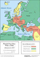
The map on the left shows the countries/empires that existed prior to WWI, as well as the alliances systems. Please be sure that you are also aware of the geographic location of "the Balkans".
This link is a good interactive map that shows the way in which the map of Europe changed after WWI, due to the break-up of empires and the creation of new countries. The Paris Peace Conference that occurred at the end of the war offered the "winning countries" a chance to re-draw the borders of Europe, and you will notice significant differences to the map.
Comments
Post a Comment